Topography assistant
By GeoSoftware


Application designed for surveying of all types, such as stakeout, measurement and calculation of areas with adjustable resections calculations and report calculations, direct intersections, remote height measurement, and ability to enter values for custom calculation.
At any time you can access through the application itself, any text file we have on the phone's SD card, with data from our control points, points for staking, etc..
In the tool "area calculation" tool and "remote height", we record our work in a text file, easily manageable by any software tool.
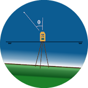
AZDH, Azimut and Distance, is an application designed to support topographers and / or engineers, which includes a calculator with basic trigonometric functions and transformation between different angular units; it provides a practical tool to calculate the flat coordinates of a point from a...

Convenient surveying calculator, including traversing, leveling, coordinate calculation and intersection...It has a powerful function to balance the misclosure in open route, closed route and link route.If you are a surveyor on the construction site, this surveying tool can assit...

TopoDroid - Cave surveying on AndroidTopoDroid helps you to take survey data and accurate sketches while you are in the cave, so that you can detect errors in the data while you are still on the spot and correct them. TopoDroid has many functions to help you get the most out of a survey...

Fast Surveys with Tablet or Smartphone.INTRODUCTIONThis application, installed on a mobile device with Android operating system, allows the user to make surveys using integrated GPS with its nominal precision, in a fast and easy way.It can be used by surveyors and other te...

Using your GPS you can take your position with an high precisionKnow your Latitude and Longitude in WGS84 degrees formatFor each position you can know which is the accuracy and the satellites used to take itSave you location with a name and export them in:✓ CSV (you...
A little gift for all surveyors, and a great app for everyone!Practical application includes:- A compass, which at the same time we can see that we azimuth from north.- A bubble level to level based, or any surface you need.- A detailed weather report, which include...

If you like movies, you need this app! You will always be up to date on upcoming movies, and you have all the information of any movie you want. All this thanks to its powerful search engine, and the huge database of IMDB.

Do you always forget where you've parked your car? Are you in a mall with a huge parking lot and you are not able to distinguish your car? Are you confused? Well, with this app, your phone will remember where you left your car, and takes you there easily and intuitively. Using a map, guide you...
Updated my previous Survey application with all revised and updated functionality. Tweaks to the design of the windows, for convenient and easy use are included. Calculations generated a minute error in the previous version are reviewed.At the same time, through this application, you ca...


